Location, lot and zoning
The map, the lot's size and shape, the building's floors and units, and what zoning allows on the lot — and how condominium apartments are handled.
Three cards describe the physical property: where it is, how big the lot and the building are, and what the lot is allowed to be. Most of it comes from the City's own tax-lot file, so you see it even without an account; the figures BlockLot works out from it — unused buildable area, rent-stabilized units, the land use — need a plan.
Location
The Location card shows the building on a map of New York City, with a pin on the lot and the lot's boundary drawn from the Department of Finance tax map. The other lots on the block are drawn faintly around it. When you are signed in with a plan, hover over a neighboring lot to see its address and click it to open its page.
The map lets the page scroll past it, so a long page stays easy to read. Use the + and − buttons in its corner, or follow the hint the map shows, to zoom. It starts close on the lot and can zoom out to the whole city, which helps when you do not know the borough well.
Under the map are two links, Open in Google Maps and Street View. They open the same spot on Google's site in a new tab; nothing is sent to Google unless you click them.
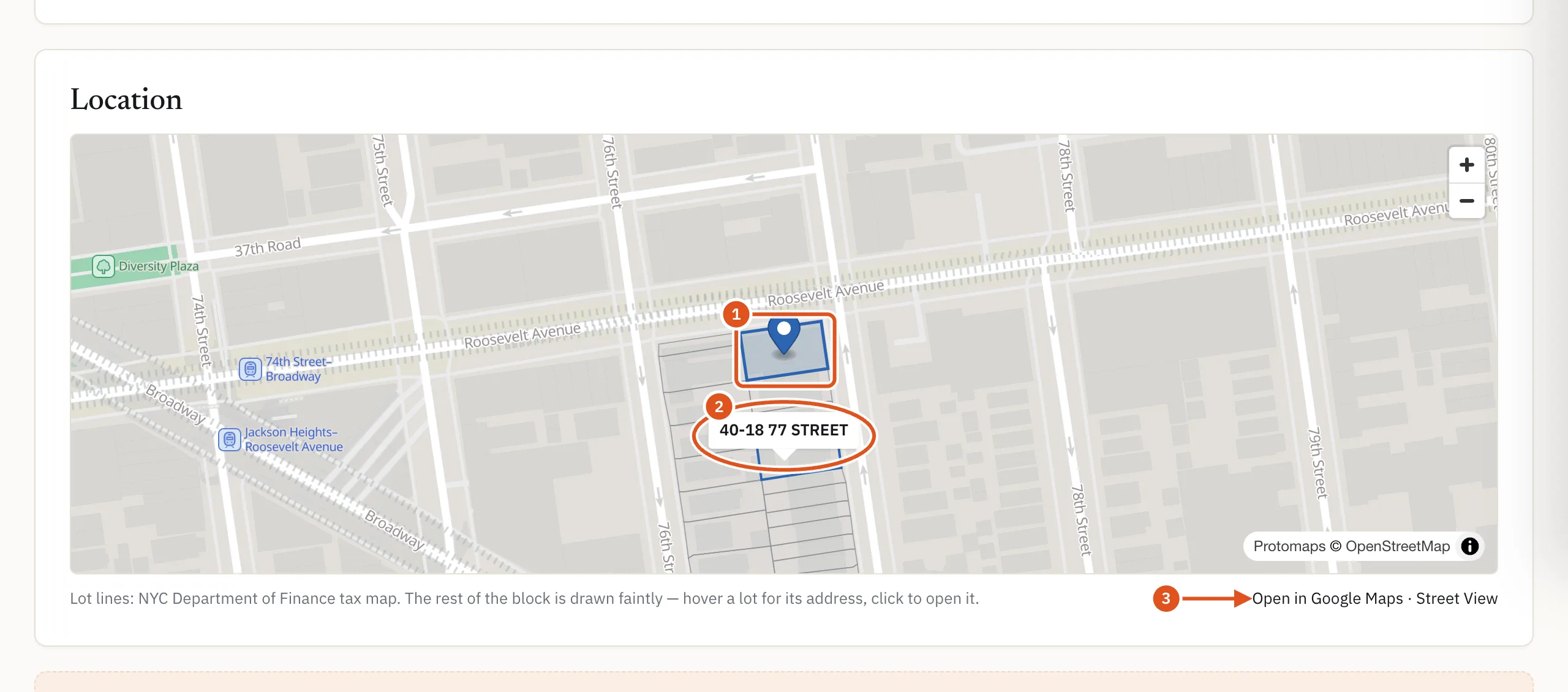
- This lot
- Hover or click a neighbor
- Open on Google
The map needs JavaScript; without it the two links still work. It is not in the PDF, which draws a printed lot plan instead — see The PDF report.
Lot & building
Lot & building gives the figures recorded on the tax roll, from PLUTO — the City Planning Department's file describing every tax lot:
- Lot area and Lot dimensions, in square feet and feet of frontage by depth.
- Building area, Building dimensions, Floors and Year built.
- Units, as a total and the residential share. A store building may show units but no residential units: its units are shopfronts.
- Rent-stabilised, when the building pays the City's rent-stabilization fee. The number of units is worked out from that fee, which is billed per registered unit, and is labeled with the tax year it covers. Where BlockLot holds an earlier year, that year's figure follows for comparison. No line does not mean no stabilized units: an owner who did not register is not billed.
- Condominium — yes or no.
- BIN, the Building Identification Number the Buildings Department uses, with a link, C of O on DOB BIS ↗, to the building's certificates of occupancy on the City's site.
A dimension the roll does not record shows a dash and not recorded, never a zero.
Zoning & use
Zoning & use says what the lot is allowed to be. It lists the Zoning district and Land use codes (click a code to read what it means) and four floor area ratios — Built FAR (what stands today) and the Residential, Commercial and Facility allowances. FAR, the floor area ratio, is permitted floor area as a multiple of lot area: an FAR of 2.0 on a 5,000 sq ft lot allows 10,000 sq ft.
Governing FAR names which allowance applies to this building's use, and Air rights turns the gap into square feet. When there is room to build, the card's headline reads buildable sq ft unused, with the arithmetic beside it so you can check it. When the building already exceeds its allowance, the headline gives the square feet over it, marked likely non-conforming — often a legal older use, or space the roll does not record, and a reason to talk to the owner either way. When the inputs do not add up, the card says Air rights need manual review rather than guessing.
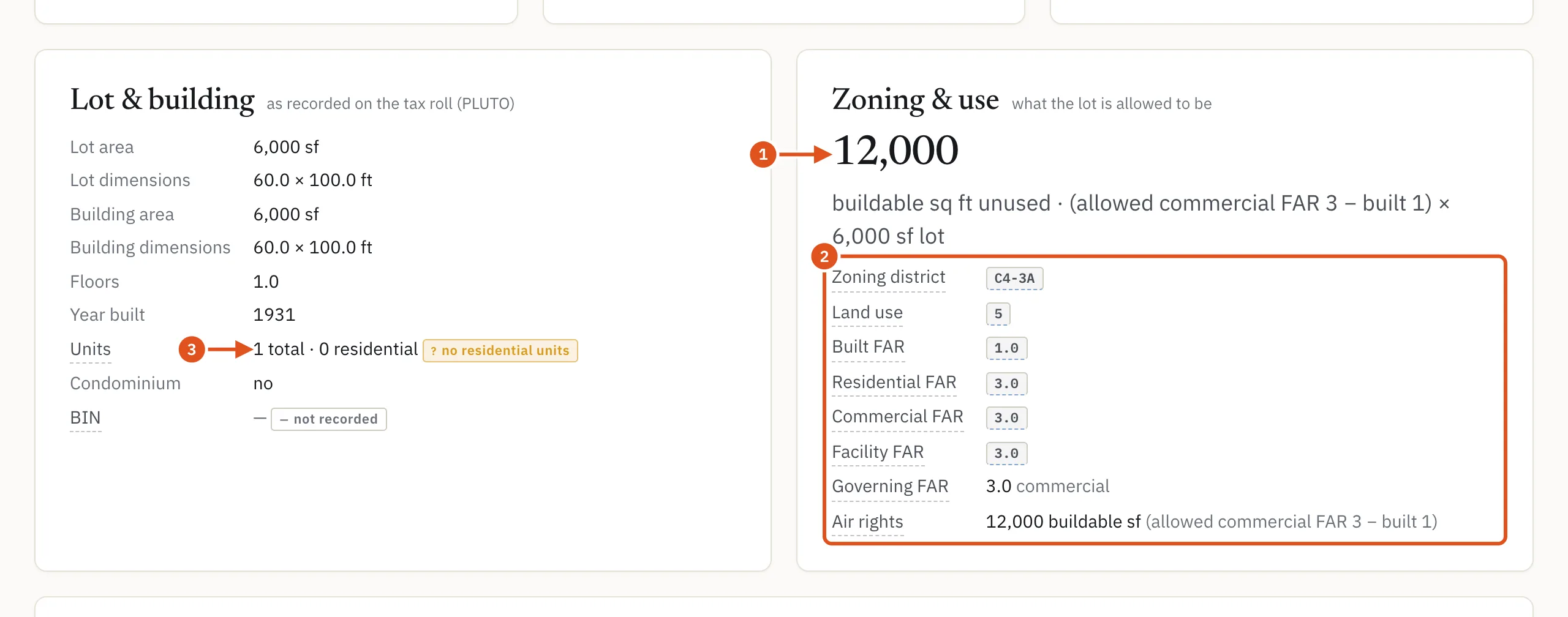
- Unused buildable area
- Built vs allowed
- Total and residential units
Condominium apartments
In New York each condominium apartment is its own tax lot, numbered from 1001 up, while the land belongs to the condominium as a whole. BlockLot follows that:
- Search for an apartment by adding it to the address, for example "#22N". If that apartment is a tax lot, the results lead with its own lot; if not, you get the building, with a note saying no lot matched that apartment. Rental apartments are not tax lots, so they cannot be found this way. See Searching.
- The header shows the apartment after the address, and so does every list that shows that unit.
- Lot area, lot dimensions and FAR read held by the condominium's base lot, marked not a unit-level figure, because the apartment owns no land of its own.
- Condominium reads yes, with the unit lot number.
- The map may borrow the building's point, marked condominium's lot: the pin then marks the building, not the apartment.
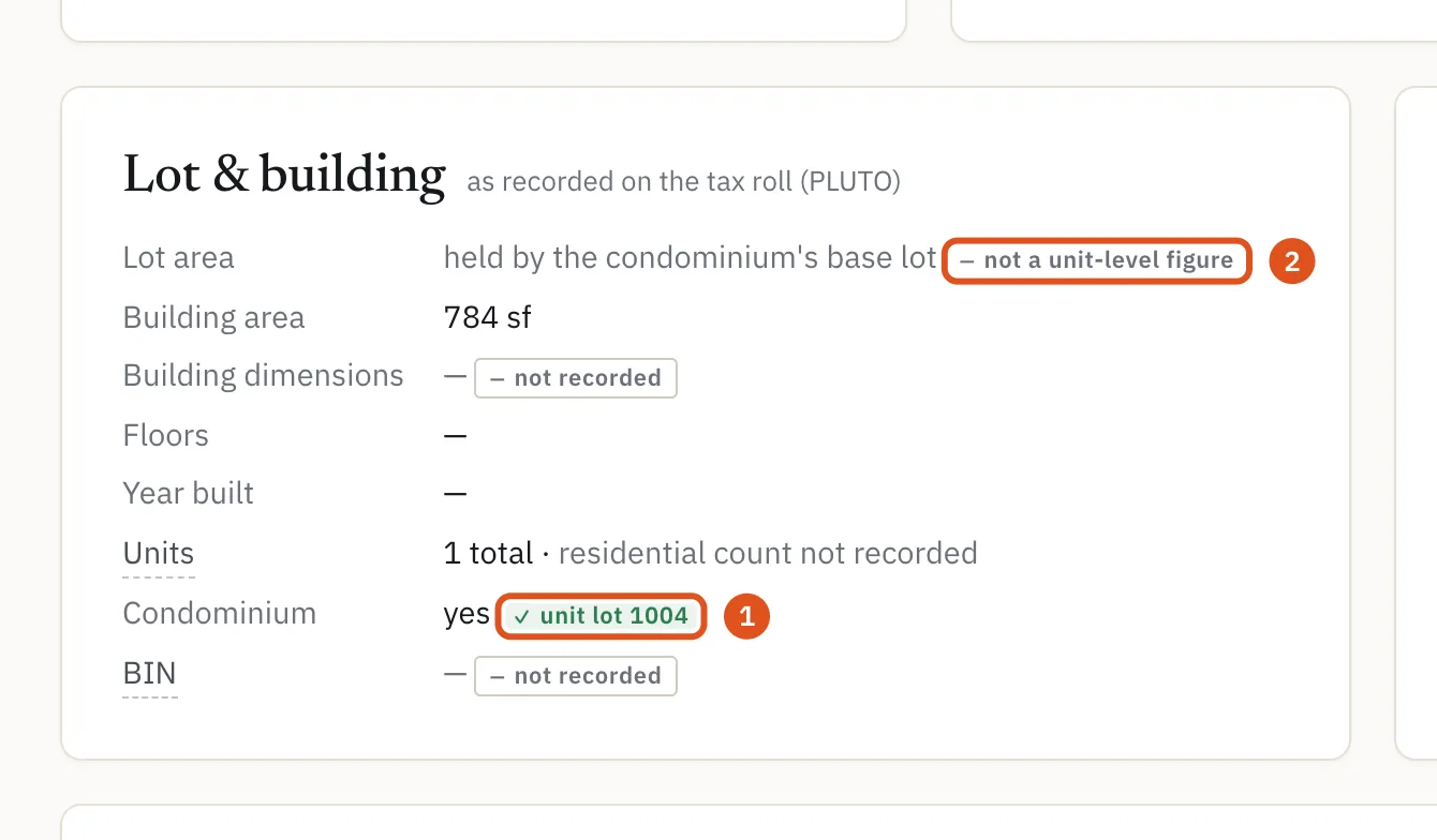
- The apartment's own lot
- Held by the building
Related
Flood zones, the hurricane evacuation zone, the police precinct and the census tract are in the Neighborhood card at the foot of the page — see The neighborhood. The block's own figures are in On this block and on the block page.