Learn NYC property · Zoning and land use
Flood zones and hurricane evacuation zones: FEMA's maps, NYC's projections and Know Your Zone
What a FEMA flood zone (VE, AE, A, X) and a base flood elevation mean for a New York City property, why the City uses both FEMA's 2007 map and its 2015 preliminary map, what the projected floodplains show, and how the six hurricane evacuation zones differ from all of them.
A flood zone — a FEMA flood zone — is an area on the flood map of the Federal Emergency Management Agency (FEMA), labelled by letter for how likely it is to flood: VE, AE, AO and A are high-risk, shaded X moderate, and unshaded X minimal. For a property near the water the flood zone decides whether a mortgage lender must require flood insurance and how a new or rebuilt building must be raised and floodproofed.
A hurricane evacuation zone is something else: one of six areas NYC Emergency Management may order to evacuate when a coastal storm approaches. A building can be outside every flood zone and still be in an evacuation zone, or the other way round, so a buyer, owner or tenant should check both.
The Flood Insurance Rate Map
FEMA's Flood Insurance Rate Map (FIRM) is the official map of a community's flood hazard. It marks the special flood hazard area, the zone letters and the base flood elevation.
- The special flood hazard area is the land a 1% annual chance flood would cover — a flood with a one-in-a-hundred chance of happening in any year, often called the "100-year floodplain" or simply the 1% floodplain. The name misleads: City Planning notes that a home there has about a 26% chance of flooding over a 30-year mortgage.
- The shaded X zone, or 500-year floodplain, lies between the edge of the 1% floodplain and the reach of a 0.2% annual chance flood: moderate risk, outside the special flood hazard area. Unshaded X is minimal risk.
The letters inside the high-risk area say what kind of flooding to expect:
| Zone | What it means |
|---|---|
| VE | Coastal flooding with waves of 3 feet or more |
| AE | 1% flooding, with a base flood elevation |
| AO | Shallow flooding, 1 to 3 feet deep |
| A | 1% flooding, high risk |
The base flood elevation (BFE) is the height the water is expected to reach in the 1% flood, in feet above a fixed reference level; on the map, "AE 13" means an AE zone with a BFE of 13 feet. The building code requires most new buildings in the floodplain to put their lowest floor at least 2 feet above it.
Two maps at once
New York City has two FEMA maps in use, for different purposes.
- The effective flood map, revised on September 5, 2007 — with amendments in 2008 and 2018 — is the legal flood insurance map. It decides whether a lender must require flood insurance. Its elevations use an older reference level, NGVD 29.
- The preliminary flood map, issued by FEMA in December 2013 and revised on January 30, 2015, shows a larger floodplain. It never took effect for insurance: the City appealed it in June 2015, arguing that FEMA had overstated flood heights by about 1 to 2.5 feet, and in October 2016 FEMA accepted the appeal and agreed to redraw the city's maps. But the City's building code uses it in the meantime: a new or substantially improved building must meet whichever map is stricter.
Ten years on, FEMA has published no new preliminary map for the city. Its September 2026 notice to Congress lists no New York City county among the maps it expects to issue through November 2026, and once a preliminary map is out, an appeal period and a six-month wait follow before it takes effect. Several pages of the City's flood-maps website still say the new maps are expected in 2016 or 2017; they are out of date.
How many lots each map touches, by City Planning's flags — a lot counts if any part of it is in the 1% floodplain, even when its buildings are not:
Lots any part of which is in FEMA's 1% annual-chance floodplain, as City Planning's lot file flags them. The 2007 map is the one in force for flood insurance; the 2015 preliminary map is the one the City's building code also applies. BlockLot Intelligence, computed October 10, 2026.
The preliminary map touches 1.9 times as many lots as the effective one. City Planning's 2016 analysis of the preliminary map put about 400,000 residents, 72,000 buildings and 183,000 homes inside its 1% floodplain.
By BlockLot Intelligence's count of FEMA's flood layer for the effective map, 26,838 lots have their centre in the special flood hazard area — fewer than the lots that merely touch it — and their median base flood elevation is 10 feet.
Each lot's point tested against FEMA's flood map for New York City. Lots in the area of minimal flood hazard (unshaded X), most of the city, are not shown. BlockLot Intelligence, computed October 11, 2026.
Flood insurance
Standard homeowners and renters policies do not cover flood. Flood insurance in New York comes mostly through FEMA's National Flood Insurance Program (NFIP), which usually takes 30 days to start. Since 1973 federal law has required lenders to make borrowers insure a building in the special flood hazard area when the loan is federally regulated or backed; the City lists the same trigger for past federal disaster aid. In shaded or unshaded X no federal rule requires a policy, though a lender may. Since FEMA's "Risk Rating 2.0", in force for all policies from April 2023, the price depends on the building's own flood risk — distance to water, elevation, the cost to rebuild — rather than on its zone letter; the map still decides who must buy.
The City's projected floodplains
Because sea level is rising, the City publishes maps of where the floodplain may reach in future decades. The Future Floodplain 2020s on NYC Open Data, published in 2013, is the 500-year floodplain for the 2020s: FEMA's working maps of that year with 11 inches of sea-level rise, the New York City Panel on Climate Change's high-end projection, added. Its 1% part keeps FEMA's zone letters. City Planning's newer Coastal Flood Hazard Mapper projects floodplains to 2150 from the panel's 2024 projections. None of these maps is regulatory: they are for planning, and they do not decide insurance or the building code.
BlockLot's "Flood zone" row on a building's page is the 2020s projection, so it is marked as projected, not the effective map. By BlockLot Intelligence's count, 54,807 lots fall in its 1% part.
Each lot's point tested against the City's Future Floodplain 2020s, drawn in 2013 from FEMA's working maps of the time with the sea-level rise the New York City Panel on Climate Change projected for the 2020s. Not the flood-insurance map. BlockLot Intelligence, computed October 10, 2026.
Hurricane evacuation zones
NYC Emergency Management divides the coastal city into six hurricane evacuation zones. Zone 1 is the most likely to flood from a storm surge and is told to leave first; when a storm comes, the City orders evacuation zone by zone, from 1 upward, depending on its strength and track. The zones were renumbered 1 to 6 in 2013 and redrawn in 2021 from the National Hurricane Center's storm-surge model, which moved about a million New Yorkers into a different zone. They are based on storm surge, not on FEMA's flood maps, and the City asks residents not to use flood zones to decide whether to leave. More than 3.1 million New Yorkers live in the six zones, by NYC Emergency Management's 2021 count.
By BlockLot Intelligence's count, 334,254 lots — 38.9% of the city's — lie in an evacuation zone, holding 40.2% of its homes.
Each lot's point tested against NYC Emergency Management's evacuation zones. Zone 1 is told to leave first. Lots outside every zone are not shown. BlockLot Intelligence, computed October 10, 2026.
Know Your Zone is the City's campaign and lookup: the Hurricane Evacuation Zone Finder, or 311, gives the zone for any address.
Rules that follow the flood zone
- Building: the Department of Buildings applies Appendix G of the Building Code to new buildings and substantial improvements in the flood zones, using the stricter of the two FEMA maps; a FEMA letter removing a lot from the zone changes the insurance but not the building rules unless it meets the preliminary map's heights.
- Zoning: the Zoning Resolution has a chapter of special rules for buildings in the 1% and 0.2% floodplains, amended in 2021, meant to encourage flood-resilient building; a few of the most exposed neighbourhoods — Broad Channel, Hamilton Beach, Gerritsen Beach, Edgemere and buyout areas on Staten Island — are Special Coastal Risk Districts, where new density is limited. Since City of Yes, no accessory dwelling unit may go in a basement or a backyard in mapped flood-risk areas.
- Flood disclosure: since June 21, 2023, every residential lease in New York State must say whether the home is in FEMA's 1% or 500-year floodplain and disclose any flood damage the landlord knows of. Since March 20, 2024, the property condition disclosure statement a seller gives a buyer asks about flooding — the floodplain, required insurance, past claims and federal aid — and the old $500 credit for skipping the form is gone.
A worked example: the Empire State Building
The Empire State Building, owned by a company, sits on high ground in Midtown: FEMA's effective map puts its lot in zone X, minimal flood hazard, and it is outside every evacuation zone. The risk sits along the waterfront: the chart of evacuation zones above counts the lots that are not so lucky.
Where you see this in BlockLot
A building's page lists its flood picture in the Neighborhood card: the 2020s projected zone (marked as projected), whether the lot touches the 1% floodplain on FEMA's effective and preliminary maps, the FEMA zone letter at its centre with the base flood elevation, and its hurricane evacuation zone. A block's page counts its lots by FEMA zone and evacuation zone.
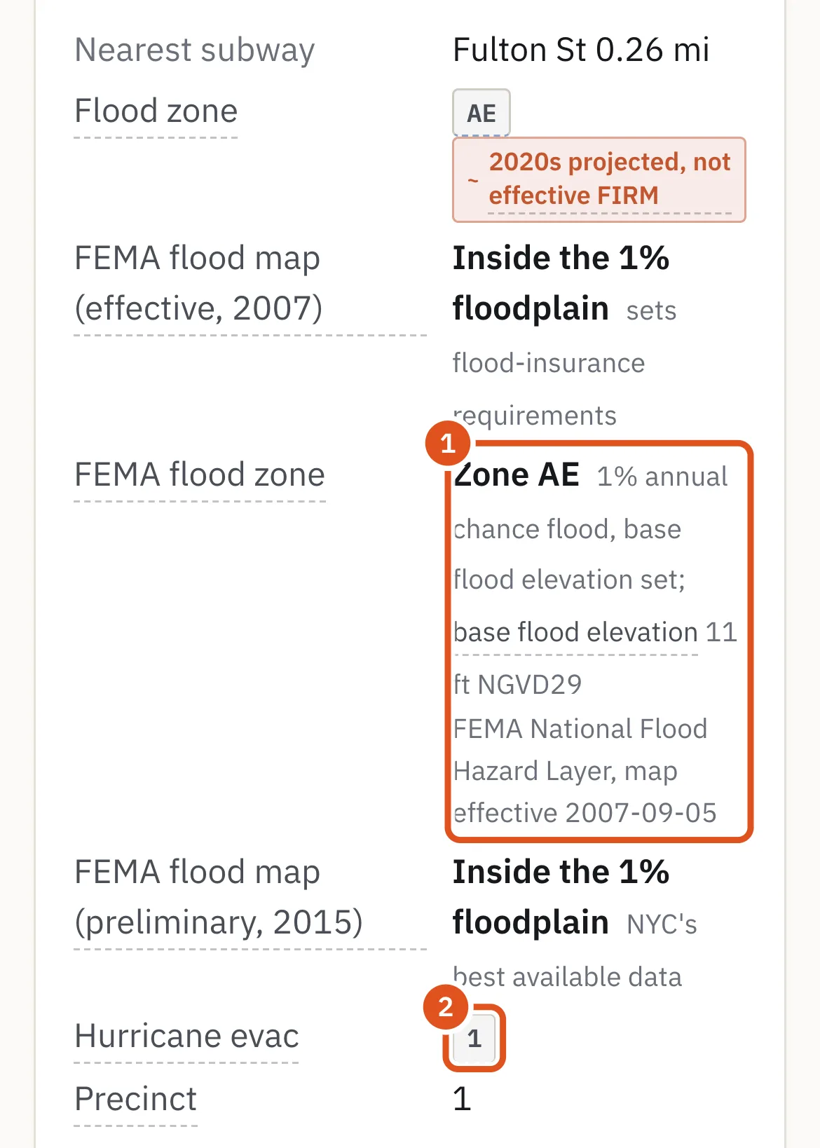
- the zone at the lot's centre
- NYC Emergency Management's zone
Questions people ask
How do I find my flood zone in New York City? FEMA publishes the effective map for any address, and the City's flood-maps website shows both the effective and the preliminary maps. BlockLot shows both on every building's page.
Is flood insurance required in NYC? Only if the building is in the special flood hazard area on the effective 2007 map and has a federally backed or regulated mortgage, or received federal disaster aid. Elsewhere it is optional, though often sensible: homeowners policies do not cover flood.
What does flood zone AE mean? A high-risk area with a 1% chance of flooding each year, where FEMA gives a base flood elevation — the height the water is expected to reach.
What is the difference between a flood zone and an evacuation zone? A flood zone comes from FEMA's map and governs insurance and building rules; an evacuation zone comes from NYC Emergency Management's storm-surge model and says when to leave in a hurricane.
When will New York City's new flood maps come out? FEMA has set no public date. Its notice to Congress of September 2026 lists no New York City map through November 2026, and a new map takes at least a year from its preliminary release to take effect.
Does a landlord have to tell me about flooding? Yes. Since June 2023 every residential lease must say whether the home is in a FEMA floodplain and disclose flood damage the landlord knows of.
Related
- Zoning districts: R, C and M, overlays and special districts — How New York City's Zoning Resolution divides the city into residence, commercial and manufacturing districts, how to read a code like R7A or C4-5X, and what commercial overlays, special purpose districts, limited height districts and split lots add.
- City of Yes and Mandatory Inclusionary Housing: the zoning changes of 2023 to 2024 — What the three City of Yes zoning amendments changed — carbon neutrality, economic opportunity and housing opportunity — with the Universal Affordability Preference, parking, accessory units and conversions, and how Mandatory Inclusionary Housing requires affordable homes in rezoned areas.
- Lot size, frontage and depth: corner lots, through lots, irregular lots and wide streets — How New York City measures a lot — its area, frontage and depth — what makes a lot a corner, through or interior lot, why irregular lots and wide streets matter under zoning, and what the minimum lot sizes became after City of Yes.
- Department of Buildings (DOB) — What New York City's Department of Buildings does, how a building permit works from filing to sign-off, what a Certificate of Occupancy is, and how DOB violations and stop work orders are issued and cleared.
- Landmarks and historic districts: what designation by the Landmarks Preservation Commission means — How New York City designates individual, interior and scenic landmarks and historic districts, what an owner must do afterwards — permits, upkeep, fines — and how a landmark can sell its unused floor area.
Sources
- BlockLot Intelligence — BlockLot's own analysis of the public records below, computed October 11, 2026.
- FEMA — Flood Insurance Rate Map (FIRM)
- FEMA — Flood zones
- FEMA — Zone VE
- FEMA — Zone AE
- FEMA — Zone AO
- FEMA — Base flood elevation
- FEMA — Flood insurance laws (mandatory purchase)
- FEMA — Risk Rating 2.0
- FEMA — National Flood Hazard Layer
- FEMA — Notice to Congress of flood map changes, September 2026
- NYC Building Code, Appendix G (flood-resistant construction), as amended by Local Law 77 of 2023
- NYC Flood Maps — about the flood maps and the 2016 appeal
- NYC Flood Maps — appeal overview
- NYC Flood Maps — map overview (zones and BFEs)
- NYC Flood Maps — flood insurance
- DCP — Flood Risk in NYC, information brief (November 2016)
- Zoning Resolution, Article VI Chapter 4 (flood zones)
- Zoning Resolution, Article XIII Chapter 7 (Special Coastal Risk District)
- NYC Emergency Management — Hurricane evacuation
- NYC Emergency Management — Know Your Zone
- NYC Emergency Management — changes to the hurricane evacuation zones (June 1, 2021)
- NY Real Property Law § 231-b (flood disclosure in leases)
- NY Real Property Law § 462 (property condition disclosure)
- NY Senate — S5400 of 2023 (Chapter 484, flood questions and the end of the $500 credit)
- NY Department of Financial Services — flood insurance
- DCP — PLUTO Data Dictionary, August 2026 (26v2): FIRM07_Flag, PFIRM15_Flag
- NYC Open Data — Future Floodplain 2020s
- NYC Open Data — Hurricane Evacuation Zones