The block and the neighborhood
What the property page says about the block around a building and its neighborhood — storefronts, sales, crime, mortgage lending and zoned schools.
Two cards on the property page step back from the building. On this block puts it among its neighbors with a few figures from the block page. Neighborhood gives context about the area: transit, flood maps, crime in the precinct, mortgage lending in the census tract and the zoned public schools. Use them to judge the location, not the building itself.
On this block
The card's subtitle names the block. Below it is a set of figures for the block, shown when the block has them:
- Storefronts, Storefronts vacant and Named storefront businesses, from the owners' Local Law 157 storefront filings and the businesses on record.
- Anchors, chains with many locations elsewhere, with their names listed under the figures.
- Sales, last 24 months and Median $/sq ft, last 24 months, counting single-lot sales with a stated price and leaving out condo units.
- New-building, major-alteration & demolition permits, 12 months.
- Lots in a distress band, the lots whose distress score is moderate or worse.
- Unused buildable floor area, a rough estimate: what zoning allows on each lot, less what is built.
- Lots held by the largest owner, grouped the way the property page groups owners.
Click a figure to open the rows behind it. Opening those from the building's page costs nothing more. When the building fronts a street, a line compares the storefronts on This side with those Across the street.
The buttons at the bottom go further: Open the block page → shows the whole block with its map, Street frontage → compares the block faces, and a corner lot adds Intersection: buttons for the blocks around the corner. See The block page.

- Figures for the block
- The whole block
Neighborhood
The card's subtitle is comps context — not distress signals: it describes the area, not the building's condition. At the top:
- Nearest subway and its distance.
- Flood zone (the City's projected flood map for the 2020s, which is not FEMA's effective map), FEMA flood map (effective, 2007), FEMA flood zone with its meaning and base flood elevation, and FEMA flood map (preliminary, 2015). When only part of a lot is in the floodplain, the card says so.
- Hurricane evac zone, the police Precinct and the Census tract.
Crime
Crime shows NYPD complaint counts for the building's police precinct over recent full years: felonies, misdemeanors and violations, and the precinct's felony rank among all precincts, where 1 is the quietest. These are precinct totals and are not adjusted for population. A busy commercial precinct can rank high without being more dangerous per resident.
Mortgage lending
Mortgage lending summarizes the mortgage applications lenders reported under the federal Home Mortgage Disclosure Act (HMDA), year by year, for the building's 2020 census tract: applications, loans originated, the denial rate, home-purchase loans, the investor share, and the median purchase loan, home value and borrower income. As the heading says, these figures describe the tract, not this building: HMDA records carry no address. A note gives the tract's income compared with the metro area.
Zoned schools
Zoned schools lists the public schools the address is zoned for, by level, with the share of students scoring at Level 3 or 4 in English and math (the Maths column), attendance, and the share of students attending more than 90% of school days (Attend 90%+; the rest are chronically absent), from the Department of Education's School Quality Reports. Zoned is not eligibility: it is where a child is entitled to a seat, and middle and high school admission is screened or by lottery in much of the city. Charter, private and District 75 schools are not zoned.
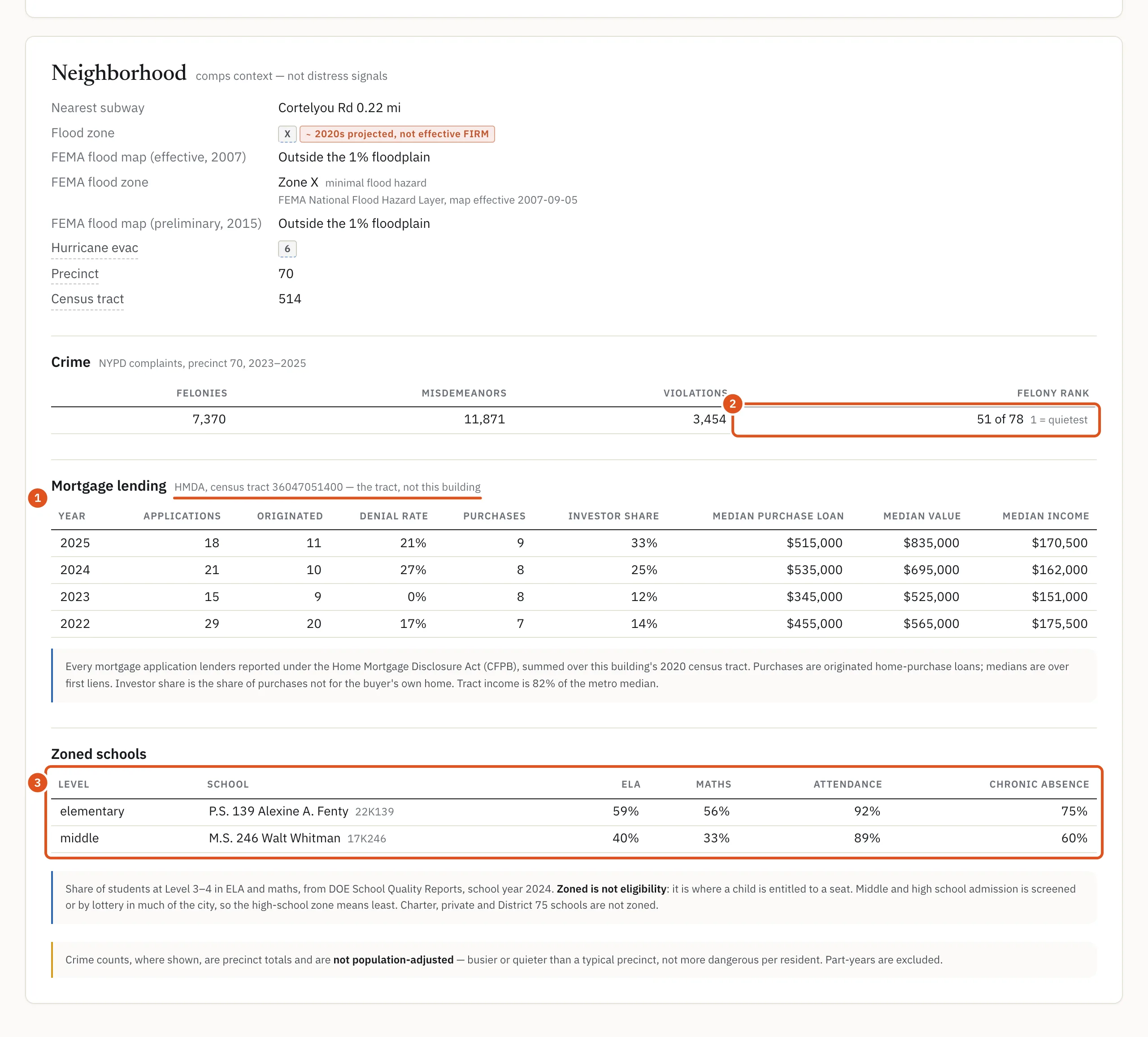
- Tract figures, not the building
- Precinct rank
- Schools by level
Going further
The block page, the ZIP page and the census tract and neighborhood pages put many buildings side by side. See The block page and Census tract and neighborhood pages.
Who sees what
Visitors who are not signed in and free accounts see both cards with the private figures hidden: block sales, prices and distress counts, the flood and precinct details, and the crime, lending and school figures. Public facts such as the block's storefront and permit counts and the census tract number stay. With a plan, opening the building's full report counts once against your monthly allowance and shows everything.